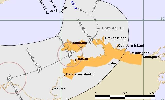
The northwest Top End, including Darwin, is officially on cyclone watch.
Subscribe now for unlimited access.
$0/
(min cost $0)
or signup to continue reading
A tropical low located 250km north of the Tiwi Islands is forecast to intensify and move southeast towards the Top End north coast, according to the Bureau of Meteorology.
The official forecast track has the system intensifying into a Category 1 Tropical Cyclone tomorrow evening, the bureau says.
A cyclone watch has been declared for parts of the northwest Top End, including coastal locations between Daly River Mouth and Milingimbi, which includes Darwin and the Tiwi Islands
A cyclone watch provides communities within the watch area early information about the risk of sustained gale force winds (greater than 60km/h) within a 24 to 48 hour period of the watch being issued – the watch is upgraded to a warning when impacts are expected within 24 hours
The system is expected to brush past Darwin, and the impacts on Darwin are expected late Friday evening, with a wet and windy night forecast
Darwin could see heavy falls with 24hr rainfall totals of 100-150mm, potentially up to 200mm
Wind gusts with a category 1 cyclone are between 95 and 125km/h, which are similar speeds to the gusts seen during the last monsoon burst in early February
These potentially severe weather conditions are likely to be brief for Darwin, and will ease from Saturday afternoon
The impacts of gale force winds at this time of year (after plenty of rain) could result in some trees coming down, and possible disruption to power, telecommunications and transport routes
A Flood Watch will be issued for northwest coastal rivers later today.
The most likely track is for the system to pass between the Tiwi Islands and the Cobourg Peninsula tomorrow night and before moving into the Van Diemen Gulf, offshore from Darwin
It’s possible the system may cross the coast further to the east of the Coburg peninsula. In this scenario, the system will weaken over land before approaching Darwin so sustained gales would be less likely for the city and rural areas, however some heavy rain and damaging wind gusts may still cause localised power, telecommunications, and transport disruption
If a cyclone does form, it will be named Tropical Cyclone Marcus, and will be the first NT tropical cyclone for the 17/18 cyclone season
It is unlikely that this system will spend long enough over NT waters to develop into a severe tropical cyclone (category 3 or greater) before affecting the north coast of the Top End


