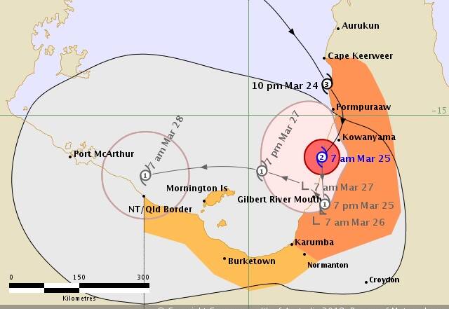
Tropical Cyclone Nora has crossed the Queensland coast near Gilbert River mouth as it reached a severe Category 3 yesterday.
Subscribe now for unlimited access.
or signup to continue reading
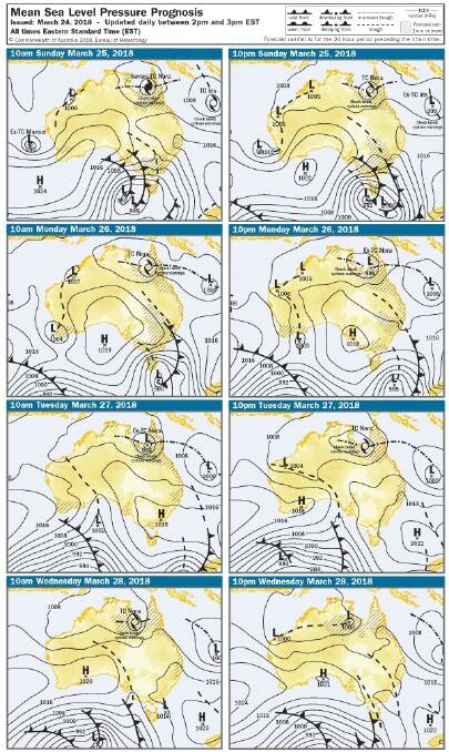
The Bureau of Meteorology is now predicting the cyclone will head west in the middle of next week and track across the bottom of the Top End as a rain depression although rain forecasts for Katherine still expect low totals.
Tropical Cyclone Nora, Category 2, is slowly weakening as it tracks southwards over land near the western Cape York Peninsula coast, between Kowanyama and Gilbert River Mouth.
The system is expected to continue moving south or southsoutheast over land and slowly weaken to a tropical low tonight near the southwestern base of Cape York Peninsula if it stays over land.
However, the cyclone may move south along the coast during today and tonight and weaken at a slower rate than expected.
If the cyclone remains on its current track and weakens to a tropical low, it is likely to move back over water in the southeastern Gulf of Carpentaria on Monday night or on Tuesday, where it may reintensify to a Category 1 cyclone.

Over 10,000 community members in the affected areas of Queensland have been told to relocate to housing above the storm tide area.
Nora is headed towards the community of Kowanyama.
Queensland Premier Annastacia Palaszczuk warned communities and residents to take Cyclone Nora seriously.
“Weipa and Arakoon are starting to feel the force of these winds now,” Ms Palaszczuk said.
“We have been speaking to local Mayor’s about supplies and getting the message out to people in the community who are vulnerable.”
Residents have been told they have two hours to make final preparations in anticipation of the Category 3 system.
The Premier said some residents have already left Mornington Island.
Spokesperson from the Bureau of Meteorology, Bruce Gunn said very destructive winds at the core of the system are estimated to be 195 km per hour and the system is 100 kms wide.
Assistant Commissioner Bob Gee, State Disaster Coordinator said there will be a certain stage when it will not be safe for anyone to be out.
“This includes the police, SES and health professionals, so please heed the warnings and get to a high place of safety. Lock down and stay there until it is safe to come out.”
Mount Isa is expected to receive heavy rainfall and flood watches are in place.

